Military Radar Defence Lines of Northern North America: An Historical Geography
Roy J Fletcher
Department of Geography, University of Lethbridge,
Lethbridge, Alberta, Canada, T1K 3M4
Received October 1989
ABSTRACT. Northern Canada and Alaska from 1945 to 1951 had only a minor military presence and no radar surveillance of airborne threats. Fear of Nuclear attack from the USSR led to the installation of numerous radar stations between 1951 and 1958. Alaska gained an inner and an outer arc of radar stations, and Canada the Pinetree Line, Mid-Canada Line, Distant Early Warning (DEW) Line and the little-known Pine-Gap radars of the east coast, from Newfoundland to Baffin Island. The Mid-Canada Line closed in 1965 and the Pine-Gap stations were dismantled nine years later. The Pinetree and DEW lines ceased operation in 1988. Alaskan radar facilities were upgraded in the mid-1980s, and in 1987 and 1988 similar radars were installed at the 14 stations of the North Warning Line, built along the abandoned DEW and Pine-Gap sites from northwestern Alaska to Southern Labrador. Very long-range over the horizon radars at three locations will be completed by the early 1990s to monitor aircraft in the vicinity of Alaska and the east and west coasts of Canada. The ballistic missile early warning radars installed in the early 1960s in Alaska and Greenland received major improvements in the late 1980s.
Contents
Introduction
Early Radars
Pinetree Line (1954-88)
Polevault and Pine-Gap (1957-75)
Mid-Canada Line (1957-65)
Distant Early Warning Line (1957-88)
Alaska Radar Network
North Warning System
Other Early Warning Radars
Conclusions
Acknowledgements and References
Introduction
During the Cold War the Soviet Union, western Europe and North America placed great reliance on radar networks to provide early warning of airborne nuclear attack (Dose 1983; Jockel 1987). From the early 1950s isolated stations were constructed in Canada, Alaska and Greenland in order to identify unfriendly aircraft (search or surveillance radars) and to direct the fighters that would intercept them (search and height-finding radars). This article describes the ground-based radar defence lines of northern North America over the past four decades.
Though general descriptions of their character and continent-scale maps of their locations have been published (Jockel 1987), little information on individual military stations, including radars, is available for public inspection. There are many, rather dated, non-technical articles dealing with the radars in Arctic Canada and Northern Alaska (for example Morenus 1957 and La Fay 1958) but very little is known of those elsewhere in North America. Much information on existing and even abandoned stations remains secret. When declassified it usually is difficult to find unless the researcher has access to military libraries such as those of the Department of Defence in Ottawa.
Early Radars
Rotating surveillance radars were installed at military bases near the Atlantic and Pacific coasts of Anglo-America during World War II to provide navigational assistance to allied aircraft and, in Alaska, to warn of enemy attack. These search radars gave target distance, speed and direction. For example, a self-contained 50 man radar station was constructed on Tigalda Island in the Aleutians to provide early warning of possible Japanese air attacks on Dutch Harbor 100 km to the west and Cold Bay to the east. The search and warning functions of these stations ended in 1945 when several were abandoned.
By 1948 potential cold war airborne threats from Siberia were watched in Alaska by one full-time radar in the northwest, and four other sets operated a few hours a day (North American Air Defense Command 1973). That year the two or three stations in Arctic and sub-Arctic Canada (Goose Bay, Labrador and probably Frobisher Bay, Baffin Island and Whitehorse, Yukon) were not in a search and warning mode. But, with the development of Soviet thermo-nuclear weapons and of long-range aircraft capable of carrying them to inland targets, some sort of early warning screen was needed. Temporary radar networks, using obsolescent equipment, were set up at 44 sites in the US in 1949 and early 1950 to protect potential targets in the industrial northeast and Great Lakes areas, Washington and California. These stations received updated search radars in 1950, and during 1951 and 1952 a further 85 stations were added (Grant 1957). The Ground Observer Corps was formed in 1950 to provide visual identification of aircraft spotted by the radars. By 1957 the Corps has 350,000 volunteers in the US and 80,000 in Canada (Air Force 1957).
Pinetree Line (1954-88)
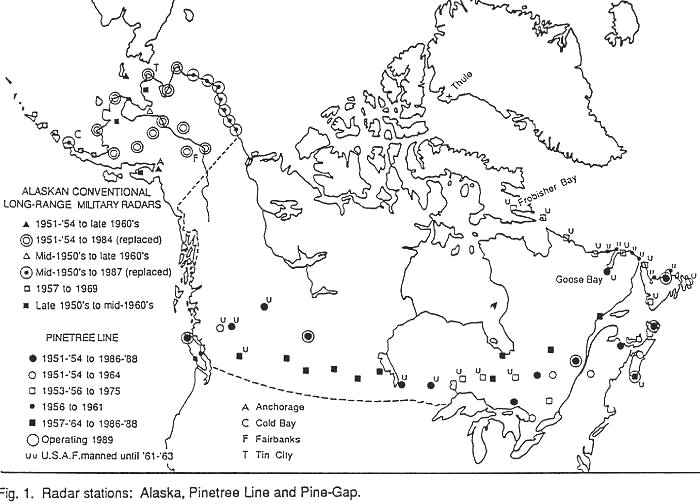
The US desired a double screen of overlapping radars to provide earlier and more reliable warning of air attack on the eastern heartland, and to direct fighter interceptors. This required radar stations in eastern Canada, and an agreement in 1951 lead to the construction of the Pinetree radar stations across southern Ontario, Quebec, British Columbia and Atlantic Canada. This part of the line was completed by 1954. Figure 1 The US Air Force (USAF) financed and manned almost all of the stations west of the Ontario-Quebec border and more than half of those in Atlantic Canada. The Royal Canadian Air Force (RCAF) built and operated all the radars in Quebec.
As air defence emphasis changed to the protection of bomber bases of the US Strategic Air Force, a second phase of Pinetree construction, 1957-64, filled in gaps in the prairie provinces, northern Ontario and Quebec. All were paid for by Canada and manned by RCAF. The North American Air Defence Command (NORAD) was created in 1858 to integrate US and Canadian radar and fighter interceptor operations, with control centres at North Bay, Ontario, Anchorage, Alaska, and within conterminous United States.
In the early years each Pinetree station had 300-400 personnel of whom about one-third were civilians. Operations sites had a main building with an elevated, medium-range (75-100 km) search radar. On either side, connected by covered passageways, were a height-finding radar and a back-up search radar. Wind damage led to the housing of the radars inside 15-metre diameter inflated rubber domes. Some stations also had back-up height-finder radars inside a fourth dome, but the main FPS-6 height-finder was high-powered, very reliable and accurate at long range. It was twice modified, but remained in use from the early 1950s to the mid-1980s.
Domestic sites had two-storey barracks and a mobile home park accommodating 30-50 trailers for married personnel. Unless a large town was nearby, there was also an area of 30 to 50 transportable, double-width, single family homes. There were separate buildings for power, heating, administration, school, library, fire station, recreation centre, maintenance, sewage and water treatments. Some stations had a swimming pool and a golf course (Canada, Department of National Defence, various dates).
With the introduction of supersonic aircraft, tracking, identification, plotting, reporting and communicating became too slow. Therefore in the early 1960s computers were installed to speed up data processing. The Semi-Automatic Ground Environment (SAGE) system included 275-tonne computers (58,000 vacuum tubes) at the control centres and smaller computers at each radar station. These small computers were large enough to require a separate building, the SAGE annex. Automation reduced personnel to 120-200 per station, including 50-70 civilians (Canada, Department of National Defence, various dates). Back-up Interceptor Control (BUIC) centres with solid-state computers were set up by NORAD in the 1960s to take over if the computers at the main control centres were inoperative. The two Pinetree Line BUICs were at St. Margaret’s, New Brunswick and Senneterre, Quebec.
In the mid-1960s back-up search radars, if present, were removed and a few years later the back-up height-finding radars were dismantled. Pinetree stations had solid state computers and new search radar technology installed in the early 1970s, increasing their range to about 300 km, and facilities to counter electronic jamming and identify whether an aircraft was friend or foe (IFF). Operational and maintenance staff were reduced to 30-40 (Kvas 1987). The increase in radar range and reliability permitted the closing of several stations in the mid-1060s and mid-1970s. Figure 1
By 1982 the costly and outdated SAGE facilities at the control centres were replaced with more powerful solid-state computers and the BUIC function ended. NORAD reorganized its defence zones so that there would be seven Regional Operations Control Centres (ROCCs). Two centres (Canada, East and West) are at North Bay to control airspace over Canada and one is at Elmendorf Airbase, Anchorage, replacing Alaska’s three manual control stations. Today the final identification and interceptor control functions are performed at each ROCC by about 20 operators at large video display consoles (Stein 1983).
Almost all the Pinetree stations closed 1987-88. Radar facilities were removed and the attached residential areas were sold, often for a small fraction of their construction cost. Several have been converted into self-contained retirement villages or residential suburbs. Out-dated radar technology and high operating costs were factors in the decision to abandon the line. New radars were needed that were further north or of much greater range, and that could detect low-flying cruise missiles.
Polevault and Pine-Gap (1954-75)
During World War II the USAF built and manned very small airbases at Fort Chimo, northern Quebec, Coral Harbour, Southampton Island and Frobisher Bay, southern Baffin Island as refuelling and emergency stops on the Crimson Staging Route to transport 24,000 warplanes from the US to Europe (Canada, Department of National Defence, various dates) Larger airbases were constructed at Goose Bay, Labrador and in Green land at Sondre Stromfjord, Angmagssalik and Narsarssuaq. The USAF withdrew from the small bases in 1945 but returned in 1951 to Frobisher Bay and expanded facilities at the larger airbases, especially at Goose Bay. Goose Bay grew rapidly in the 1950s to become Canada’s largest military airbase. From then until it passed to Canadian control in 1971 the base had at various times numerous B-52 bombers, fighter interceptors and tanker refuelling aircraft. Today Goose Bay is used as a low-level flight training base for fighter aircraft of Germany, Great Britain, the Netherlands and Canada.
Dundas or Thule, NATO’s only large fighter interceptor base in the Arctic, was built in northwestern Greenland in 1951. Operation Bluejay required 140 ships to transport construction supplies and equipment. At its peak the base had over 12,000 American servicemen. In recent years about 250 military and 1200 (mostly Danish) civilian personnel maintain the base and operate the Ballistic Missile Early Warning System (BMEWS) super-long-range radar complex installed in 1960 (Hanley 1987). No combat aircraft are currently stationed at Thule.
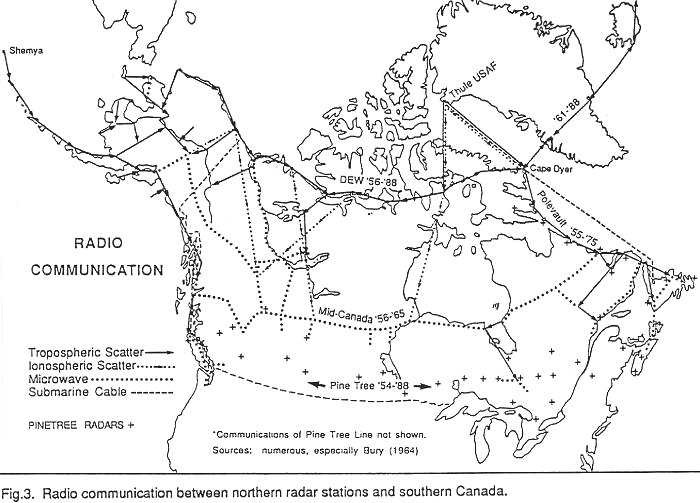
Until recently one of the weakest links in the defence of Arctic areas was communication. Short-wave radio is subject to blackouts due to magnetic disturbances in the atmosphere. Thule, Goose Bay and other bases needed a reliable voice and teletype connection with the south. The solution to this problem was the installation of the Polevault tropospheric scatter line. Troposphere scatter uses an ultra-high frequency FM radio signal, not suitable for television, that is usually transmitted at 1 KW (Bury 1964). Due to differences in temperature, density and humidity within layers of the lower atmosphere, some of the energy is refracted over the horizon. Sensitive receivers pick up as little as one ten-trillionth of the transmitted signal. It was a reliable, expensive, brute-force method of obtaining at least 70 voice channels. Most stations had round, 9 m diameter, dish type antennae that permitted a transmission range of about 200 km.
For greater range the transmitted power could be increased, but only at considerable expense since the stations had to produce their own electricity using diesel oil generators. Instead, the sensitivity of the receivers was increased by making the antennae larger. Square "billboard" antennae 18m and 36m across allowed a maximum one-hop communication of up to 1100 km. These large antennae had built-in furnaces to melt ice from the screen’s face. Military tropospheric scatter stations in Arctic North America were usually manned, even if no radar was present, and they were "doubled", with two antennae pointing in each of two directions: if one unit failed there was an automatic switchover to the other.
Built in 1954-55, Polevault extended from Frobisher Bay to Gander, Newfoundland. Figure 3 In 1956 the line was extended to Cape Dyer at the eastern end of the Distant Early Warning (DEW) Line, then under construction, and its line capacity increased. A submarine telephone cable was laid from Thule to Newfoundland by way of Cape Dyer in 1959. Icebergs, storms and fishing trawlers cut this cable several times during the 1960s. Thule was connected to Polevault by a "long-hop" tropospheric scatter to Cape Dyer in 1960, and indirectly by way of the DEW Line at Hall Beach in 1964 (Bury 1964). The Polevault line was sold to Bell Canada in 1974 when satellites took over military communications.
Long-range radar stations were constructed at tropospheric scatter sites along the Polevault Line in 1955 (Figure 1). Smaller gap-filler search radars were placed between them from southeastern Newfoundland to Hopedale, Labrador the following year. Since these radars connected the eastern ends of the Pinetree Line and the just-completed Mid-Canada Line, they were collectively called the Pine-Gap, Gap-Pine, Pacer Pine or Pinetree Filler. Built and manned by the USAF, their existence was unknown to the Canadian public. Infrequent news releases dealt with other radar lines but not with the Newfoundland and Labrador radars.
The four largest stations, at St. Anthony, Cartwright, Hopedale and Frobisher Bay had both search and height-finding radars under geodesic domes, and were each manned by about 130 military personnel. Living quarters were similar to USAF Alaskan herring-bone design of 20-25 separate rectangular buildings connected by long heated passageways. There was a long-range search radar and fewer buildings at the two Polevault sites between Hopedale and Frobisher Bay (Saglek and Resolution Island). The six medium-range gap-filler stations south of Hopedale had one radome, a helicopter pad, oil tank, one or two small buildings, and a small lake or reservoir nearby.
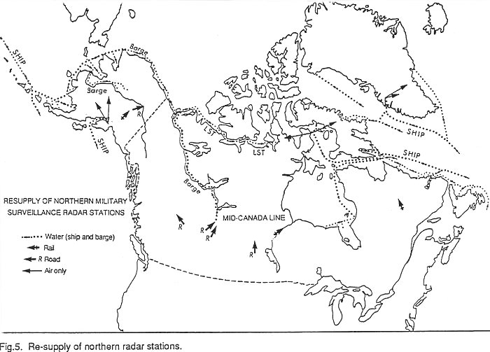
For the first few years the US Navy carried out the annual resupply, then the Canadian Navy or Coast Guard took over, using commercial ships. Figure 5 Usually several ships were used including combined cargo-tanker vessels. The stations were on 300-400 m hilltops, so the off-loading and movement of supplies were often difficult. Saglek in northern Labrador was especially windy, and the next station north, Resolution Island, had the most dangerous resupply because of the exposed anchorage and the uneven airstrip. Gap-filler stations were closed in 1961 and the remainder of the Pine-Gap radars in 1975. Recent aerial photographs show that of several stations, for example Saglek, only foundations of buildings remain. At such stations as Resolution Island where removal of structures would have been difficult and expensive, the buildings were abandoned.
Mid-Canada Line (1957-1965)
In 1954 construction of the Mid-Canada Line (or McGill Fence) began in response to pressure from the US and Canadian air forces and the Eisenhower administration (Diubaldo and Scheinberg 1978). Most of the construction costs of the Pinetree and Pine-Gap radars had been borne by the US. Thus, Canada decided to design, build and operate a doppler radar fence that, if broken by a southbound aircraft, would provide an early warning. Several doppler patterns were tested and a double-line 5-10 km apart with stations every 100 km was selected (Lester 1977). The two-line system provided an aircraft’s approximate position, direction of crossing, track and, in some cases, its speed (Canada, RCAF 1957).
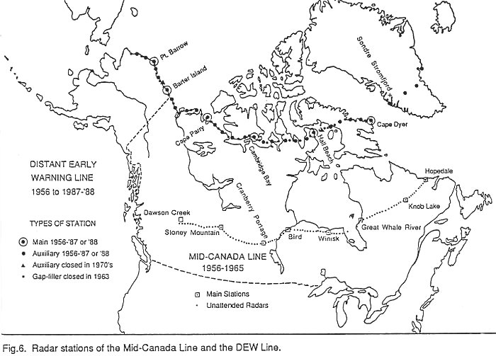
Ninety unmanned radar stations and eight large section control stations were built between 1954 and 1957 along 55 degrees North from Hopedale, Labrador to Dawson Creek, British Columbia, where they ties in with the Pine-Gap and Pinetree radars Figure 6. Roads and railroads provided relatively easy access to sites in the western portion of the line, but in Quebec and Labrador construction materials had to be brought in by float and ski-equipped aircraft. A few large lakes allowed ice landings by large, wheeled cargo aircraft. The area south of Hudson Bay had considerable muskeg, so winter tractor trains (tractor pulling 6 to 8 sleds or wagons weighing 5-7 tonnes each) were used. Supplies were also brought in by ship to Great Whale River, Quebec and Winisk, Ontario, which were section control stations. Radar sites at the north end of James Bay were entirely supplied by sea. During 1956, the year of most active construction, 50 chartered fixed-wing aircraft and 43 helicopters (RCAF, RCN, USAF and civilian) were operating (Lester 1977). The line became fully operational 1 January 1958 although most sections were functioning several months earlier.
The unmanned stations were serviced by maintenance personnel from the control stations. Doppler antennae facing opposite directions were at the top of guyed towers 15 to 100 m high. Four microwave communication antennae lower on the tower passed signals 50 km to the nearest station on the other line of stations in an almost flat zig-zag route. There were also an equipment building, a survival hut with beds, plumbing and cooking facilities for maintenance crews, fuel tanks and a helicopter pad. Most doppler and microwave equipment were in duplicate and there were three diesel engines, each capable of carrying the full electric load of the station.
Section control stations had a permanent staff of about 150. There was an operations building, an aircraft or helicopter hanger, a firehall, living quarters, and buildings for messing, food storage, power and heating, administration, recreation, motor vehicles, laundry, sewage disposal, and water treatment (Lester 1977). Three control stations, Knob Lake, Quebec, Cranberry Portage, Manitoba and Stoney Mountain (Gregiore Lake), Alberta, that were astride heavy traffic routes, were equipped with conventional rotating surveillance radar. Control stations were supplied by sea, rail or road. Figure 5 Contact was maintained with the radar stations by helicopter and small float-equipped aircraft. Radar data was sent to the nearest control station by microwave, and processed before being forwarded to major NORAD control centres such as North Bay. Southward communication was by commercial land lines and microwave in western Canada, and by military microwave and tropospheric scatter (Polevault) in the east. A short tropospheric scatter line which had to be built across James Bay was extended south to the Pinetree Line Figure 3.
With the introduction of faster jet aircraft, the additional early warning time that the Mid-Canada Line provided, did not, by the mid-1960s, justify the expense of operating the network. The western portion of the Mid-Canada Line was closed in January 1964 and the remainder in April 1965 (Thorne 1982). An evaluation of aerial photographs of many sites indicates that the radar and microwave equipment was dismantled and removed as well as all buildings and other structures at the more isolated control stations such as Stoney Mountain. At established settlements, like Great Whale River, the airstrip and its facilities were put to good civilian use.
Distant Early Warning (DEW) Line (1957-1988)
By international agreement the US from 1957, planned, built and largely funded a radar line along the 66th parallel from northwestern Alaska to eastern Baffin Island. DEW Line settlements were the northernmost in Alaska and close to the edge of Canada’s ecumene. Along or north of this line of 63 tiny military establishments there were in Canada only about 600 Inuit, RCMP and weather observers. In spring 1955 sites were selected by inspection from the air and by ground evaluation, meeting the requirements that the stations be about 160 km apart, be of sufficiently high elevation and that construction gravel be available (Harwood 1966).
Small earth-moving tractors were parachuted into some sites so that a temporary airstrip could be built, allowing aircraft to deliver larger tractors. Convoys of about 60 ships each sailed from Seattle, Washington and Norfolk, Virginia in the summer of 1955. Many ships were damaged by the ice and by bow-stern collisions. Construction equipment and fuel were off-loaded and airstrips and landing beaches prepared. The sealifts of 1956 and 1957 were of similar magnitude and brought buildings and electronics. Barges on the Mackenzie River and winter tractor trains in Alaska were also used. After the permanent airstrips had been built there were 2800 supply flights, many by large Globemaster transporters. There were about 60 crashes and 30 related deaths (LaFay 1958). Construction crews totalled 7500 Canadians; 1100 US soldiers unloaded the ships.
The DEW Line had doppler radars every 80 km, transmitting signals that would bounce off any object that crossed their beam and sound alarms at the nearest auxiliary station. (See Figure) Auxiliary stations, 160 km apart, had rotating long-range search radar with a range just great enough to reach stations on either side. There were a few places where a narrow gap in coverage would occur if a station were shut down for repairs. These reliable radars had two channels (low and high-scan angle) that theoretically covered the surface to 15,000 m but in the area mid-way between adjacent stations the earth’s curvature prevented reliable monitoring below 200 m (Canada, National Archives 1962). The low-level gap was to be covered by doppler radars but these gave so many false readings that some observers were "…cancelling the alarm without even inspecting the scope for target presence" (Canada, National Archives 1958). On the other hand, aircraft, especially if at low elevation or slow speed or flying along the line, were slipping through unnoticed (Canada, National Archives 1957).
The most typical DEW station was the auxiliary which had a rotating radar with a 17 m diameter plastic geodesic dome and two doppler radar antennae on a guyed steel tower. Data from these were displayed on two screens and watched by a single observer. Processing was done by tube-type computers and all electronics were doubled to prevent shut-down. These stations were operated by 10-20 men, mostly ex-RCAF civilians in Canada and ex-US Navy in Alaska. There was one long building. The train, composed of 25 prefabricated modules which provided electric power and boiler rooms at one end, operational rooms, living quarters and a radome supported on stilts above the roof. Additional buildings were a large warehouse, a garage and a small house for Inuit employees. A short (1300-1400 m) gravel airstrip, often with a seldom used hangar, was located nearby.
Ideally, the radar settlement, airstrip, off-loading beach and a deep freshwater lake were close together. Sewage was piped to the sea or to a lake, well-removed from the water supply. There was a cluster of eight to ten short-wave radio towers and four round tropospheric scatter antennae. At the off-loading beach there was a gravel ramp to deep water but no dock. A pipeline led from two fuel tanks near shore to identical tanks near the building site; "Arctic diesel" was used for everything except aircraft. Aerial photographs show that in the 1960s and 1970s many stations had large, rectangular rubber fuel bladders at both the airstrip and radar areas. Crated dry goods were stored outside in rows. The buildings at several Alaskan stations and at the westernmost in Canada were quite different from the train type elsewhere. They had seven or eight small buildings (largest with radome) connected by a central passageway.
There were six "main" stations 800 km apart, performing the same functions as the auxiliary sites, but also providing southward communication and servicing of the smaller stations. Airstrip and tropospheric scatter facilities were the same, but the fuel tanks were larger and the central building complex was composed of 40-70 modules in two or three trains connected by a central passageway. There were four or five warehouses and several garages.
Doppler radars were at all stations but they were the only radar at "intermediate" ("I") sites. These stations had a small, five-module building with power plant and temporary quarters for a maintenance crew. There were four small (76,000 litre) fuel tanks, a 700 to 900 m airstrip, a garage and an Inuit house. These stations were to operate unmanned but, although they worked well, the initial two-man crew had so much work that it soon grew to four or six permanent staff. Several stations were difficult to build and service because they lacked a road to the beach or the runway was very short.
Between 1958 and 1960 four auxiliary stations were built in Greenland. Two were on the ice cap at 2300 m and 2600 m elevation where all equipment was housed in one, two-story, composite building with radome and enclosed tropospheric scatter antennae. It was supported by four extensible double columns that were jacked up about 1 m every year. Subsurface tunnels led to four buried fuel tanks and a sewer outfall chamber. There were several sled-mounted buildings to store runway maintenance vehicles and for emergency housing. Water was obtained by melting snow brought into the building by a drag-line bucket (Goyette 1962).
Communication of warning data was by tropospheric scatter along the DEW Line and to the south at four points. Figure 3 This system was upgraded at many stations in 1964 by replacing the 9 m round with 18 m square antennae. By 1974 US military and the Anik satellites were used to transmit data southward but the DEW tropospheric scatter network continued to function. For a few years following completion of the DEW Line five main sections had a very high frequency ionospheric scatter teletype radio communication with southern microwave stations and the Thule airbase Figure 3 The principle of transmission was similar to tropospheric scatter but the antenna was a cluster of 10-14 towers interconnected with wires. The range was 1200 to 1900 km with four teletype or one two-way voice channel. The transmitters, which required 40 KW, were expensive to operate and, being subject to solar and auroral blackout, were less reliable than tropospheric scatter. They were not used to communicate radar warning data.
Resupply almost everywhere was by sea. Cargo vessels and tankers serviced the line from eastern Greenland to Hall Beach and in Alaska. US Navy ships were used in the early years, thereafter commercial vessels under Canadian direction. Dry cargo was loaded at Ogdensburg, NY and Montreal on vessels bound for different areas: Foxe Basin, Greenland and eastern Baffin Island. By the 1980s these ships carried their own loading barges and even small tugs. Large tankers off-loaded fuel at Sondre Stromfjord in western Greenland and smaller tankers transferred it to the DEW stations. Barges brought crated goods and fuel down the Mackenzie River to Tuktoyaktuk where they were transferred to large LST landing craft for shipment to the stations in western Canada. In recent years the Alaskan stations were supplied by sea-going barges.
Off-loading took one to three days for dry cargo, and one day for fuel by floating pipe. The worst sea ice was encountered at Foxe Basin and at Point Barrow, Alaska where there was a risk of being trapped on the eastern side until the next summer. Inland stations on Baffin Island, west of Hall Beach and on the Greenland ice cap could be resupplied only by air from the main stations or, in the case of Greenland, from Sondre Stromfjord airbase. Once or twice a week cargo aircraft stationed at Hall Beach and Cape Perry distributed fresh produce, mail, magazines and movies from the main stations to all the smaller stations. In Greenland similar service was provided by helicopters and light, ski-equipped aircraft.
From 1957 until it closed down in 1987 and 1988 the DEW Line lost and gained stations and improved communications but, unlike Pinetree stations, radar technology was not substantially upgraded. Radar stations and "long-hop" tropospheric scatter antennae were constructed in Iceland, on the Faeroe Islands and the Shetland Islands, so by 1961 there was a radar screen from the Aleutian Islands to Scotland. All 31 gap-filler doppler sites were abandoned in 1963. Two auxiliary stations (Flaxman Island, Alaska and Rowley Island in Foxe Basin) were considered redundant and closed in 1970. During the 1960s and 1970s there was a perceived decrease in threat of attack by bomber aircraft in the era of the inter-continental ballistic missile and some people believed that the line’s main functions were a reliable military communications link with Europe and a navigational aid to civil aircraft. A clean-up of PCBs and other contaminants was undertaken in the mid-1980s at all abandoned stations. Most of these had become uninhabitable due to vandalism and a quarter century of harsh climate (Holtz and others 1986). But two Canadian and five Alaskan "I" stations have been used for research projects of the US Office of Naval Research, the Canadian Department of Indian Affairs and Northern Development and the Polar Continental Shelf Project.
Alaska Radar Network
Between 1945 and 1955 the USAF withdrew temporarily from the Aleutian Islands, to concentrate its defensive forces at Anchorage and Fairbanks, where there were also major army bases. Warning of Soviet air attack of these areas was provided by five temporary radars installed in the early 1950s. Radar picket ships, mostly destroyers, were stationed along the Aleutian Islands. A plan to build 37 radar stations in the state was modified and 10 were constructed between 1951 and 1954. These, together with four stations which were built earlier and better equipped, created two areas of protection Figure 1 that are present today.
The outer arc had, initially, single long-range search radars with a complete but not overlapping coverage of the coast. Most of them were located on top of hills or mountains and some, such as Tin City, the closest to the USSR, were connected to a base camp 500-800 m below by aerial tramway (O’Lone 1981). The radar antenna was within an inflated rubber dome on top of a two-storey building of similar size. Due to wind damage the rubber domes were soon replaced by others made of plastic panels. A crew of six manned the operations site and 60-80 USAF and 10-15 civilian personnel were at the base camp which was comprised of 10-15 buildings and passageways similar to the Pine-Gap stations (Loviero 1955). The civilians maintained a tropospheric scatter site. The number of personnel required to operate an outer arc station was reduced to 50-60 by 1981 (O’Lone 1981). Residential facilities at the base camp included recreational buildings for a gym, bowling alley, theatre and game lounge. Typically, supplies were delivered weekly or every other week by transport aircraft, and mail came by light aircraft several times a week. Most of the sites had 1200-1500 m gravel airstrips.
Height-finding as well as search radars were installed at the seven stations of the inner arc, including those near Fairbanks and Anchorage which functioned more as fighter interceptor control centres than as warning stations. Both types of radar were similar to those of the Pinetree Line although of longer range until the 1960s. Most stations in isolated mountainous areas had radar site and base camp separation similar to those on the coast. In several the base camp was beside an older village with established transportation facilities such as river docks and asphalt airstrips. At stations on lowlands, such as at Fort Yukon on the river northeast of Fairbanks, the radar and base camp were together. A military tropospheric scatter network, called White Alice, was completed in 1957. There were about 30 stations, half of them at radar sites, that connected the surveillance radars with NORAD’s regional control centre in Anchorage (Elmendorf airbase) by way of one of two smaller "manual" control centres (King Salmon in the southwest or Murphy Dome, near Fairbanks). White Alice connected with a microwave line along the Alcan Highway, and a branch line without radars went down the coast from Anchorage to southern British Columbia and ultimately to NORAD headquarters in Colorado. A submarine cable followed a similar route from Skagway to Washington state. The White Alice system was sold to the RCA Corporation in 1969, which operated it for the military until 1979 when it was re-sold and became a commercial telephone service to back-country Alaska. Since then communication has been by satellite. A back-up "meteorburst" system was installed in 1986 at all stations. It bounces radio signals off the ionized trails of hundreds of meteorites that are continuously entering the earth’s atmosphere (Covault 1988).
Alaska’s coastal radar stations have been re-supplied between May and October by commercial shipping companies since 1957. Cargo vessels and tankers were used for the first few years and since then by several large, sea-going barges out of Seattle. These barges are self-contained with about 2000 tonnes of petroleum and 4000-5000 tonnes of dry cargo that can be off-loaded with shipboard cranes (Curran 1974). Usually supplied are taken to a landing beach by the barge’s own lighters and fuel is pumped to shore through floating hoses. Smaller barges with tugboats are used to re-supply two stations on the Yukon River and two sites receive goods by road from Fairbanks. The stations that were the most costly to build and supply are two interior sites west and northwest of Anchorage. Their fuel requirements, until a few years ago, were met by 120-150 flights per year of DC-6 cargo aircraft converted to tankers.
Ten additional radar stations were built in the second half of the 1950s to cover the eastern Aleutian Islands area and to fill gaps along the west coast. The six Aleutian stations were considered as an extension of the DEW Line. Their buildings and radar were similar to those of the DEW Line but they had more personnel (20-30) including those at a White Alice site nearby. A decade later nine of the ten stations and two others were closed Figure 1. Only the one near the Cold Bay naval airbase was upgraded.
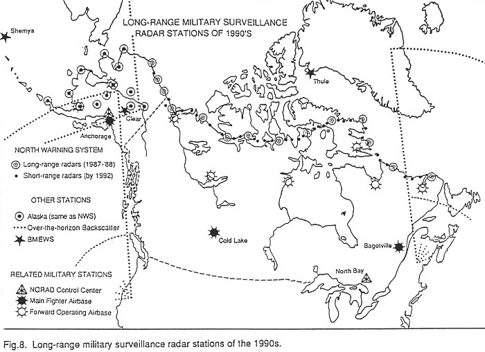
The Alaskan radars were probably better than those of the Pinetree Line in the 1950s, but they did not become part of the SAGE system with its advanced computer technology that was introduced early in the next decade. Improvements were small until 1981-84 when the "Seek Igloo" project created a Minimally Attended Radar System (MARS) at 13 stations Figure 8. The new 3-D "phased array" radars are single units in which the antenna rotates horizontally and scans elevation electronically across many small radiating elements. Their maximum range is 310 km horizontally and 30,000 m in elevation (Mayfield 1980). Solid-state electronics automatically compensate for clutter, atmospheric disturbances and jamming by hostile aircraft. They can pick out much smaller targets than before but probably not cruise missiles. The original radar building was retained but the numerous buildings at the base camp were replaced by two large geodesic dome structures for housing and equipment (Aviation Week and Space Technology 1988). There are no operators since data are transmitted directly to Anchorage but each station has 8-10 civilian maintenance people.
North Warning System
Public concern that the early warning radar lines of northern North America were becoming redundant was off-set in recent years by a resurgence of belief that Soviet aircraft are able to threaten North America (Lambert 1981). Several versions of their "Backfire" bomber are smaller than, but qualitatively similar to, NORADs B-52. The Soviet "Blackjack" bomber, which should be operational by 1989, is similar in configuration to the B1 that is in the late stage of development in the US. Both bombers have the capacity to carry large weapon loads, including cruise missiles, and they can fly very high or very low and very far for a long time (Sweetman 1988). Even if these aircraft can be intercepted soon after passing through the northern radar lines they can deliver cruise missiles within striking distance of North American targets.
The newest radar line is the North Warning System which was constructed in 1987 and 1988 to replace the outdated and costly-to-maintain radars of the DEW Line and to re-occupy the Pine-Gap Line. Figure 8 Its radars are of the same long-range, multi-elevation and multi-target phased-array type as those installed in Alaska several years before. New structures were placed at 11 existing DEW Line stations, two dismantled Pine-Gap sites and at a Polevault site on southeastern Baffin Island. The stations are maintained by 25-30 people. Until satellite communication equipment is installed, the DEW tropospheric scatter facilities will transmit unprocessed data to the two control centres at North Bay. Also there will be approximately 40 unmanned short-range (112 km) gap-filler radars that will process and correct their own data before transmission (Eleccion 1987). Construction of eight radars in Canada’s eastern Arctic and eight in the west will begin in 1990. Several stations will be at abandoned sites such as at Resolution Island. All gap-filler radars are to be installed by 1992.
Supporting the new radar screens in Alaska and northern Canada are interceptor fighter bases at Anchorage, Cold Lake and Bagotville Figure 8. Several fighters will be stationed at "Forward Operating Airbases". Two in Alaska (King Salmon and Galena) have been operational for a few years (Covault 1988) and six in Canada are under construction. Each of the Canadian bases, to be completed by the end of 1993, will have six hangars, bunk houses for up to 200 armed forces personnel and buildings for operations and equipment storage (Jackson 1988).
Other Early Warning Radars
Airborne Warning and Control (AWAC) aircraft are stationed in Alaska for rapid response there, and they can be sent to northern Canada during times of international crisis. These flying surveillance bases have a radar range of 320 km and, if refuelled by air tankers, they are able to assist or completely take over the function of the Regional Operations Control Centres and direct the air battle.
Over-the-Horizon Backscatter (OTH-B) radars detect air-breathing and rocket-powered targets by reflecting doppler radar signals off the ionosphere. They have a horizontal scan angle of 60 degrees and a range of 3000 km excluding the 700 km nearest the antenna (Eleccion 1987). Transmit and receive antennae are stationary metal structures about 1 km across and separated from each other by 70-170 km. A processing station is at a third location. Each antennae station requires a staff of about 60, and over 300 are at the processing site.
An OTH-B radar was tested in Arctic Canada and found to be inappropriate there because of electromagnetic interference in the atmosphere (auroral effects). Radars in New England are operating, those in the northwestern states should be completed in 1990 and in Alaska a few years later (Lopez 1987). Figure 8 Alaska’s operations base will be at Anchorage, transmitter at Gulkana and receive antenna at Tok. An OTH-B radar of a different design is under construction on Amchitka Island in the Aleutians to monitor the Sea of Okhotsk area. Because OTH-B radars cannot scan the area close to the antenna several Pinetree radars on Canada’s south coast were not closed when the Line came to an end in 1988.
Ballistic Missile Early Warning System (BMEWS) radars of 4800 km range were built between 1960 and 1962, first at Thule, Greenland, then Clear, Alaska and then at Flyingdales Moore, England Figure 8. Thule and Clear had, respectively, three and four antennae of the "billboard" vertical screen type, 50 by 122 m in size. All three sites had 26 m rotating dish-type detection and tracking radars inside 43 m radomes (Stein 1983, Jane’s Weapons Systems 1988-89). The BMEWS stations received new electronics in the early 1980s. In the latter half of the decade the screen-type antennae were replaced by phased-array radars of 5150 km range. This radar used a grid of 2560 elements on each of two 26-metre walls of a building containing individual solid-state transmit/receive modules for each element (Stein 1983). It can determine numerous launch and impact points and automatically transmit the information to NORAD headquarters and elsewhere. An older tube-driven phased-array radar called Cobra Dane has been on Shemya Island in the Aleutians since 1977. It is currently used to monitor Soviet ballistic missile tests and to provide early warning of launches as far away as 3200 km (Jane’s Weapons Systems, 1988-89).
Conclusion
From the completion of Alaska’s basic network in 1954 to that of the North Warning System in 1988 many radar stations have come and gone; those that survived have been upgraded several times and had reductions in personnel. The four Canadian Lines have been replaced by one that functions almost unmanned. Because all the lines except the Mid-Canada were largely funded, operated and controlled by the US there was an increasing concern in Canada for a perceived loss of sovereignty. This was reduced when Canadians replaced US personnel at Pinetree stations in the mid-1960s, and in 1988 a "fully Canadian" North Warning System existed outside Alaska.
Acknowledgements
This study could not have been completed without the kind assistance of the staff of the National Archives of Canada and the Department of Defence libraries at the Directorate of History and at Headquarters, all in Ottawa. The aerial photographs were reproduced from the collection of the National Air Photo Library of the Department of Energy, Mines and Resources. I thank also the University of Lethbridge, especially L. Wehlage.
References
Air Force. 1957. Air Defence of North America. Air Force 40(8):251-59
Aviation Week and Space Technology. 1988. Remote radar modernization cut costs, personnel needs. Aviation Week and Space Technology 129(2): 115-16.
Bury, G.J. 1964. Military communications in t-71.
Canada, Department of National Defence. Various dates. Permanent Reference Files, Ottawa, Directorate of History, Department of National Defence. (Files on individual defence establishments, bases, stations).
Canada, National Archives. Various dates. DEW Line Operations. (File S960-100-80/9 contains unbound letters and telex documents on DEW Line Operations).
Canada, RCAF. 1957. Manual for fighter control operations. Ottawa, Department of Defence, RCAF. (Amendments to July 1960)
Covault, C. 1988. Airborne intercepts bolstered with new radar data links. Aviation Week and Space Technology 129(2): 111-14
Curran, D.J. 1974 Operation Cool Barge. Sealift 24(9): 18-20
Diubaldo, R.J. and Scheinberg, S.J. 1978. A study of Canadian-American defence policy (1945-1975) Northern issues and strategic resources. Ottawa, Operational Research and Analysis Establishment, Department of National Defence.
Dose, D. 1983. NORAD: a new look. Kingston, Centre for International Relations, (National Security Series No 1-83)
Eleccion, M. 1987. A major facelift starts for strategic radar nets. Electronics 60(8): 78-81
Goyette, H.B. 1962. DEW Line Canada-Iceland link. Military Engineer 54(361): 325-28
Grant, C.L. 1957. The development of continental air defense to 1 September 1954. Alabama, USAF Historical Studies No 126, Air University, Maxwell Air Force Base.
Hanley, C. 1987. New radar switched on. Whitehorse Star, 21 August 1987: 14.
Harwood, T.A. 1966. DEW Line site selection and exploration. In: Proceedings, Permafrost International Conference… 1963, Lafayette, Georgia, Washington, DC: 359-63.
Holtz and others. 1986. Removal of contaminants from Distant Early Warning Sites in Canada’s Arctic. Edmonton, Environment Canada.
Jackson, K. 1988. NWT business feels left out by DND. News North, 22 August 1988: 17.
Jane’s Weapons Systems. 1988-89. Land based air defence, United States of America, 56-62 and Ground radar, United States of America 276-305. Jane’s Weapons Systems, 1988-89.
Jockel, T. 1987. No boundaries upstairs, Canada, the United States and the origins of North American air defence, 1945-1958. Vancouver, University of British Columbia Press.
Kvas, P. 1987. Lobster, lighthouse and long-range radar; a history of Canadian forces station Barrington to 1987. Yarmouth, Nova Scotia, Sentinel Printing.
La Fay, H. 1958. DEW Line, sentry of the far north. National Geographic Magazine 114(1): 128-46.
Lambert, M. 1981. Why the manned bomber? Intervia 4: 297-301.
Lester, A.G. 1977. Special contract: a story of defence communications in Canada. (Unpublished manuscript, copy held by Directorate of History Library, Department of National Defence, Ottawa).
Leviero, A. 1955. Lone radar sentries guard US in Arctic vigil. New York Times, 8 June, pt 14.
Lopez, R. 1987. The USA builds its OTH-B radar barrier. Interavia 4: 334-35.
Mayfield, J. 1980. Air Force upgrading radar network. Aviation Week and Space Technology 112(24): 229-32.
Morenus, R. 1957. DEW Line: Distant Early Warning, the miracle of America’s first line of defence. New York, Rand McNally.
North American Air Defense Command. 1973. The NORAD story. (History and description of the North American Air Defence Command, news release). Colorado Springs, North American Air Defence Command.
O’Lone, R. 1981. Advances expected at USAF surveillance station. Aviation Week and Space Technology 115(8): 40-45.
Stein, K.J. 1983. Region Control Centres prepare for air defence role. Aviation Week and Space Technology 119(4): 64-69.
Sweetman, W. 1988. Blackjack air defence challenge for the 1990s. Intervia 43: 1012-24.
Thorne, D.H. 1982. The Mid-Canada Line: the intermediate early warning system, 1958-65. High Flight 2(4): 143-53.
This article was provided by Kevin O’Reilly for use on the Pinetree Line web site in October 1998.